The benefits of integrating geographic information with your open data program
What holds back the sharing of geographic data and how can these barriers be overcome? Our blog shares best practice for unlocking greater value from your GIS data by making it part of your wider open data program.
Geographic data, such as that produced and stored in GIS systems, is extremely powerful. It provides key information on the location of assets (such as buildings, roads and equipment), and natural features such as rivers, mountains, and woods. These are then all displayed through accurate mapping, helping to communicate, analyze, and share data on the world around us.
The growing use of apps based on geographic data, for uses as varied as route planning and fitness, has made everyone more aware and interested in this data type. As adoption has grown, there’s a real need for organizations in the public and private sectors to develop attractive, compelling services to democratize geographical data and share it in new, innovative ways.
The barriers to sharing geographic data
However, it can be difficult to share geographic data widely. It requires technical expertise to analyze and understand it, and often needs access to specialist software to visualize and manipulate it. It is therefore often siloed within organizations and not effectively shared internally or externally. This means other employees within a company or municipality simply may not know this data exists or be able to access it confidently.
While this approach may not have been an issue in the past, the democratization of geographic information is now essential to maximize its value for all.
To be shareable and to encourage the development of new innovative use cases, geographic data must:
- Be high-quality and regularly updated
- Share a common vocabulary with other datasets through the use of shared metadata
- Be explorable through intuitive and collaborative catalogs
- Be available in different formats, including maps but also as dashboards or data stories
- Be easily reused thanks to APIs or export features
This requires integration of geographic data with wider open data and data democratization initiatives.
How do you integrate geographic and open data?
Combining geographic and non-geographic data delivers three key benefits:
- Greater access to data by all, not just GIS specialists, increasing usage and maximizing value
- Improved collaboration internally and externally as more people can understand and work together using a single source of the truth
- Opportunities for innovation, creating new use cases and services by combining different data types in a single visualization or dataset
To integrate GIS data into your wider open data strategy, deploy an all-in-one data platform that can help you create and distribute digital data experiences for all your audiences. Look for a platform that can:
- Easily link to all data sources, including common GIS programs, through built-in connectors
- Automate updates from these sources to ensure quality and relevancy
- Enrich these datasets and prepare them for reuse, such as by combining them with other, freely-available datasets
- Create visualizations (maps, dashboards, data stories) and share them on open data portals, sub-domains or apps
- Manage sharing access and enable reuse, such as through APIs that share data at scale.
Effectively sharing geographic and open data
Many organizations, across both the private and public sectors are successfully combining geographic and other data types, creating compelling data experiences for a wide range of audiences.
The Town of Cary, North Carolina
The largest town in North Carolina, Cary aims to use data to connect its communities, become smarter, and increase transparency. Users of its open data portal can download datasets, create maps and even suggest new data sources to add.
Bringing together geographic information and other data sources is key to its open data program, as these two examples demonstrate:
Stormwater monitoring
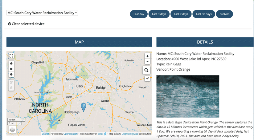
Due to its location at the heart of three river basins, Cary is prone to flooding due to stormwater surges. To provide an early warning system and to predict flooding it has installed Internet of Things (IoT) water sensors and rain gauges across the town. The water sensors send alerts when levels hit a certain threshold, and the gauges provide minute-by-minute information on rainfall.
This enables Cary officials to make faster, better informed decisions such as closing roads or greenways, rerouting traffic to prevent drivers from encountering floodwaters.
Building permits
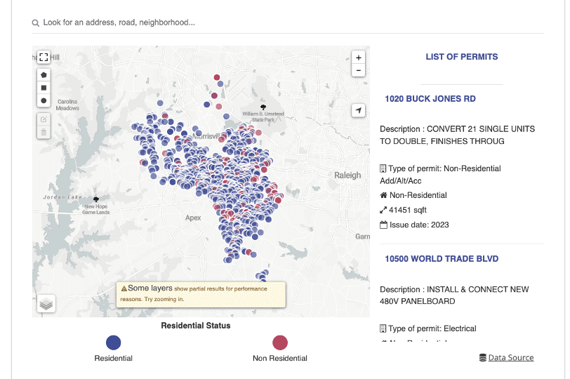
A large number of contacts received by municipalities are around building permits. Often callers are simply looking for status updates on decisions which can be provided online through open data portals. By combining GIS and permitting data sources and displaying it through an interactive, drill-down map, residents and businesses in Cary can see the exact status of permits, their location and more detail on what they cover. This increases efficiency for the municipality while improving transparency for the community.
North Carolina Office of State Budget and Management (OSBM)
OSBM is responsible for providing objective information and analysis to ensure a balanced state budget and effective stewardship of public resources. OSBM works collaboratively with agencies and departments across North Carolina to bring together their data, including GIS datasets, and make it easily available to both internal policymakers and the wider community, both inside and outside the state.
The OSBM open data portal now contains over 900 datasets, covering areas as diverse as population (including census data), labor force, education and agriculture, supplied by 20 state departments. Data series go back to 1969 and project forward to 2040. Users can also compare information about North Carolina with other states, providing instant, comparative analysis around key indicators.

ICF Habitat
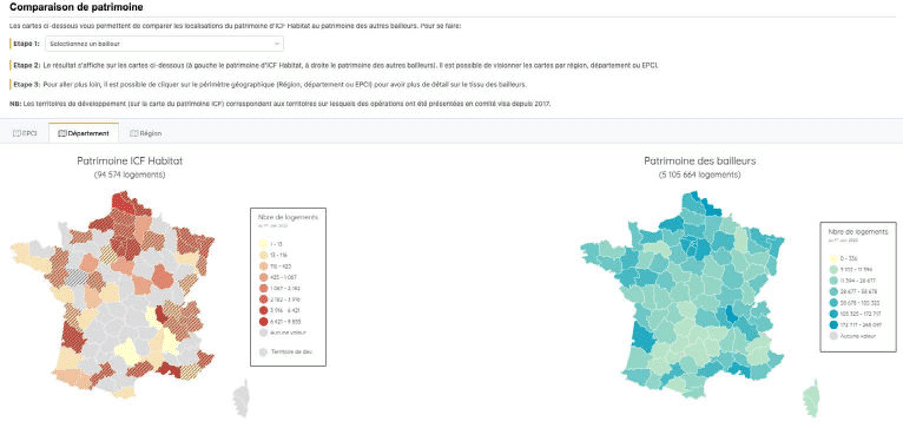
ICF Habitat is a real estate subsidiary of the SNCF Group. It manages a portfolio of 95,000 homes. To enable all the company’s employees to benefit from the advantages of data, ICF Habitat’s Real Estate Department has launched an internal self-service data platform. This includes a range of map and GIS-based datasets, including:
- Development potential – this allows users to visualize where opportunities to develop the Group’s activities have been identified, shown through maps or tables
- Action planning – providing a view of the objectives and actions implemented by each local office
- Social landlord dashboard – providing a complete picture of the total French social housing stock, across all landlords. ICF Habitat employees can filter down to specific areas and look forward to compare current and future scenarios
- A map of correlations between housing development and rail networks that allows employees to analyze the situation and make better decisions.
City of Salinas
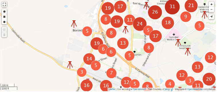
The county seat of California’s Monterey County, the City of Salinas is focused on using data to drive transparency. Its open data portal makes it easy for citizens and businesses to find the information they need, including anonymized crime data, mobility data on traffic and bikeways, and the GIS marker information used by engineering companies when carrying out construction work in Salinas. Data can be downloaded in multiple formats, visualized through maps and dashboards or automatically connected to through APIs for every dataset.
Geographic data is now ubiquitous in our daily lives. That means it needs to be effectively shared internally and externally to enable greater efficiency, uncover new uses and to drive transparency. Combining GIS data with your open data portal is the first step to unlocking this value and enabling greater data democratization.

The benefits of smart cities are universal and spread well beyond major conurbations. Municipalities of all sizes can become smart through a combination of open data, sensors and new ways of sharing information, whatever their budgets or resources.

Organizations across the world are increasingly looking at how they can turn their data into value by sharing it with their internal and external communities. To find out what is happening in the Australian market we interviewed Opendatasoft partner Peclet Technology.

