How Open Data Transforms Temporary Urbanism into Long-Term Viability
Thanks to Smart City technologies, we now have more ways than ever to gather data on urban infrastructures and understand their use. In this two-part series, we will take a look at these intersections: part 1 will act as an introduction to how tactical urbanism and open data can be complimentary.

The modern era of urbanization has picked the perfect moment to arrive in a city near you. The time of rising urban populations coincides with an unprecedented rise in new technologies that can play a role in helping cities innovate solutions to their problems. Thanks to Smart City technologies, we now have more ways than ever to gather data on urban infrastructures and understand their use.
How about combining these new Smart City and open data technologies with more tested urban development strategies, such as tactical urbanism? The philosophies behind open data and tactical urbanism have many areas of overlap: combining these approaches may be the ultimate way to pass from temporary to long-term, viable, strategic urbanism. In this two-part series, we will take a look at these intersections: part 1 will act as an introduction to how tactical urbanism and open data can be complimentary.
A Definition of Tactical Urbanism
Let’s start with a definition of tactical urbanism. Often referred to as temporary urbanism, the Tactical Urbanist’s Guide defines this strategy as “an approach to neighborhood building that uses short-term, low-cost, and scalable interventions and policies to catalyze long-term change.” Countless examples have shown the utility of short-term projects. They include:
- Inspiring action;
- Widening public engagement;
- Gathering data;
- Encouraging collaboration;
- Testing aspects of a program, project, or plan before larger investments.
Most of all, tactical urbanism projects help serve as a model to see if a project can and should be continued on a larger scale. Testing a project for a short period of time in a small area can be a strong indicator of its long-term viability. To better illustrate how tactical urbanism has been applied in practice, we can look at a few examples in transportation.
Tactical Urbanism in Transportation
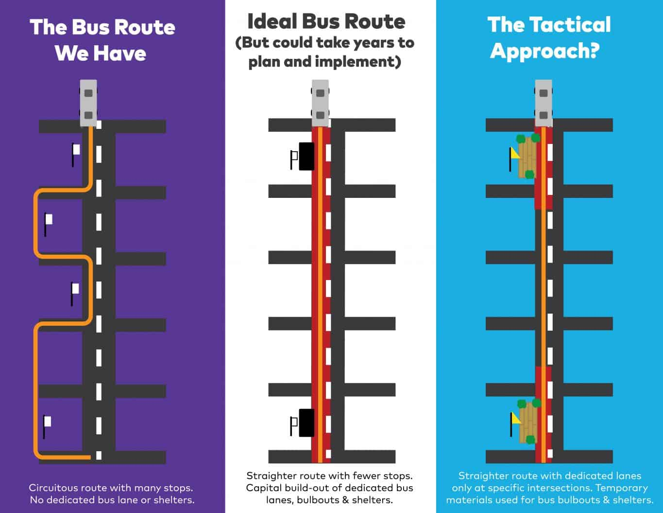
A tactical urbanism approach is frequently used in transportation. Changing and redesigning transit infrastructure is costly and time consuming, making it critical to be absolutely certain about how to and whether or not to proceed with a project. Instead of building new and permanent bus stations when redesigning a route, planners can use less expensive and temporary materials and test the new plan to see if it reduces travel time.

Tactical Urbanism can be used in transportation projects. Image courtesy of TransitCenter
City planners in Everett, Massachusetts have led a similar project. Tactical urbanism was applied to transforming a parking lane into a bus-only lane during rush hour. Using orange safety cones and temporary signs to close the lane, planners witnessed a 4-8 minute reduction in commute times for riders and overall improved circulation for other drivers.
In addition, tactical urbanism has been used in Mexico City on a project to make streets safer for pedestrians. Using once again low-cost orange traffic cones, activists created more space for pedestrians at different intersections to demonstrate the benefits of creating more spaces for foot traffic. The success of their efforts led the Mayor to announce new policies in line with the Vision Zero movement (a multinational project aiming to achieve a road network with no fatalities or injuries involving road traffic). Their efforts were largely aided by this tactical urbanist approach.
Tactical urbanism has uses outside of transportation. The transformation of Times Square is often cited as one of its biggest success stories. The common theme, however, is that tactical urbanism projects can’t be failures. Ultimately, the approach demonstrates if a project should be pursued or not, based on if it will help a city or a neighborhood. Tactical urbanism can only be enhanced by adding an Open Data layer to its application.
Tactical Urbanism and Open Data: Combining Approaches
Applying tactical urbanism strategies with open data and Smart City tech is a way not only to enhance the principles of tactical urbanism projects themselves, but also to ensure the most data-driven answers through short-term projects. The two concepts have a great deal of overlap, and are thus quite compatible.
Gather Data from the Use of Streets and Public Spaces and Deepen Understanding
Naturally, if a goal of tactical urbanism projects is to gather data, sensors could play a central role in these projects. They could measure new phenomena, such as the number of car passages per hour in Everett, to gauge how fluid traffic circulation becomes with the elimination of street parking. The real benefit would come if these data are released as open data to help citizens understand the impact of the project.
The same goes for the Mexico City example: showing the results of the activists’ street transformation could further aid their coalition building to generate more support for their project. Numbers often provide the best justification in support of change. Open data is thus a clear ally to project advocates.
Widen Public Engagement and Encourage Collaboration
Open data is a resource provided by governments and private actors to expand participation in their communities, and encourage groups to work together. Since a goal of tactical urbanism is to achieve these two participatory principles, open data can be a useful asset to a tactical urbanism project. For example, in the example of buses in Everett, let’s say the city put measures out on the location of bus stops, the number of people who used the bus, and made it possible to cross reference these data with car passages per hour. Residents could potentially help suggest additional changes and even get behind an initiative to eliminate street parking all together.
We’ve seen how open data can be a natural addition to any tactical urbanism project. Let’s look briefly at how they have been combined in Paris, in the redesign of a major traffic circle.
Open Data and Tactical Urbanism Combine in Paris
In Paris, the city is working together with Cisco to collect data on traffic, air quality, and noise pollution. Sensors measure this information in real-time, and then publish it directly onto the city’s open data portal. In addition, the data can be visualized on-site on two interactive screens to provide a clear image of what is taking place around a person. The project is being used as a test to see if such a model should be replicated and used in the redesign of other spaces in Paris: it helps to look at the scalability of the Smart City model as a whole.

Tactical urbanism and open data can help cities solve traffic flow problems
Let’s imagine the city wanted to reduce traffic and noise within the space by redirecting cars out of the traffic circle with one-way streets. They could test this using tactical urbanism: blocking off certain routes for short periods of time to find the fewest negative impacts on traffic flow while reducing air and noise pollution could be pursued. The city could test several possibilities and use the available data to include citizens, urban consulting firms, and start ups in the process. The city is in a sense making itself more transparent and participatory.
Open Data and Tactical Urbanism: Making Cities More Anti-Fragile
We have seen that open data and tactical urbanism form a complementary force in urban projects. Together, they can increase participation and transparency in driving successful projects and help increase support for changes when applied correctly. They help bring more stakeholders into the picture, and lead to a more bottom-up strategy to urban transformation. With the addition of more actors to this strategy, cities can become more anti-fragile: they are more flexible and adaptable to the challenges coming their way. Rather than holding onto an outdated belief that governments know best, they can harness the creativity of their citizens and lead better projects with more inclusive processes. At the end of the day, this type of approach would get at the heart of our participatory democracies, and prove how cities themselves can be their own urban labs for democratic society.


